

Atmospheric rivers on the Olympic Peninsula are the storms behind the region’s heaviest rain and its biggest floods. They are long bands of moist air that flow in off the Pacific and run straight into the Olympic Mountains. Here is what federal scientists say about them, and what past storms did to the park.
Quick answer
What are atmospheric rivers on the Olympic Peninsula?
Atmospheric rivers on the Olympic Peninsula are long, narrow bands of water vapor from the Pacific. NOAA says most are weak and bring useful rain or snow, but strong ones that stall can cause floods and mudslides. USGS says all of western Washington’s largest floods come from them. Strong ones from near Hawaii are called the Pineapple Express.
- On average 400 to 600 km wide, NOAA says
- Rated from AR Cat 1 to AR Cat 5
- Most park precipitation falls November to April
- Road and weather line: 360-565-3131
What an atmospheric river is
NOAA’s Atmospheric River Portal describes them as relatively narrow regions in the atmosphere that carry most of the water vapor moving sideways outside the tropics. On average they are 400 to 600 kilometres wide. A strong one carries roughly 7.5 to 15 times the average flow of liquid water at the mouth of the Mississippi River.
The U.S. Geological Survey adds that they flow in the lowest part of the atmosphere, only about half a mile to a mile above the ground. They can be hundreds to thousands of miles long.
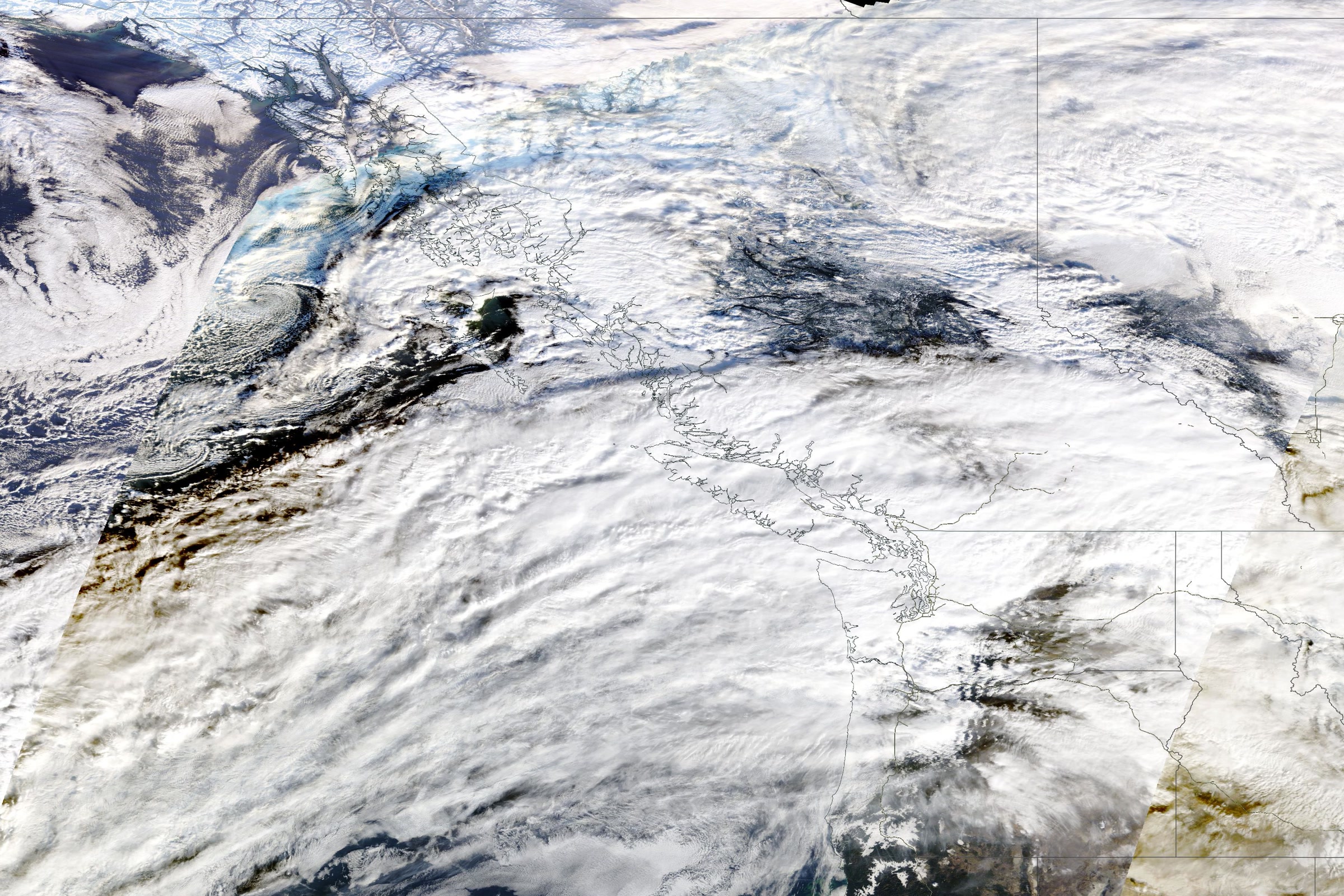
The Pineapple Express
NOAA calls the Pineapple Express a well known example of a strong atmospheric river. It earns the name by carrying moisture from the tropics near Hawaii to the U.S. West Coast. A USGS fact sheet on flooding in western Washington notes that atmospheric rivers are locally known by that name.

Why the Olympics wring them out
USGS explains that when an atmospheric river reaches the coast and flows inland over mountains, the air is pushed upward. Much of its water vapor condenses and falls as rain or snow. The park puts it simply: storms moving in from the Pacific meet a very large obstacle in the Olympic Mountains, and to cross them, the moisture must be released.
The park says the coast and west facing valleys get 100 to 170 inches of precipitation a year, most of it between November and April. Hurricane Ridge traditionally records 30 to 35 feet of snow. Our post on the Olympic rain shadow shows how much drier the northeast side stays.

Helpful rain or hazardous flood
NOAA says most are weak and simply bring rain or snow that is crucial to water supply. On average, about 30 to 50 percent of the yearly precipitation in the West Coast states falls in just a few of these events.
The strongest ones are different. NOAA says those with the most water vapor and the strongest winds can stall over watersheds and cause extreme rainfall, floods and mudslides. USGS describes a rating scale like the one for hurricanes, which runs from AR Cat 1, primarily beneficial, to AR Cat 5, primarily hazardous.
The USGS fact sheet says all of the largest floods in western Washington are caused by intense precipitation from atmospheric rivers. If one lingers over an area for a day or more, extreme flooding commonly results.
Storms in the park’s record
The USGS fact sheet lists the storms of November 6, 2006 and December 3 to 4, 2007 among those that produced western Washington’s largest floods between 1980 and 2010. Here is what the park and the state climate office recorded for those storms and for November 2021.
| Storm | What happened | Source |
|---|---|---|
| November 2006 | A section of the Hoh Road 65 feet long and 40 feet deep washed out at Twin Creek; people stranded at the Hoh walked out around the damage | NPS |
| December 3, 2007 | The Elwha reached a record 24.65 feet; just over 14 inches of rain fell at the Hoh Visitor Center in 48 hours; Highway 101 closed at Lake Crescent | NPS |
| November 2021 | Five atmospheric rivers hit Washington; Quillayute set a daily record of 4.01 inches on the 15th; a landslide on Highway 112 and debris over 101 near Lake Crescent effectively cut off the Makah Reservation near Neah Bay for two days | Office of the Washington State Climatologist (UW) |
The park said the Elwha rose 14 feet in the 24 hours before its peak, beating a high mark set in November 1949, and many sites in Altair Campground washed away. On the west side, a 750 foot section of the South Shore Quinault Road was lost.

USGS rated the atmospheric river that reached the Northwest on November 15, 2021 as AR Cat 5, exceptional and primarily hazardous.
Rain, not snowmelt, drives the floods
Many people blame warm rain melting the snow. USGS calls that a popular myth. Its fact sheet says rainfall intensity and duration cause all major floods in western Washington, and melting lowland snow adds only a small percentage to peak flows.

Visiting in atmospheric river season
The park warns that flooding and severe storms can close roads and limit access. Some closures from past floods last for years. As of October 2026, the park’s road page lists the Olympic Hot Springs Road in the Elwha Valley as closed to vehicles because of a washout. The Dosewallips Road is also closed by a washout outside the park, which is why our Dosewallips River Trail guide starts with a road walk.
- Check the forecast and call the park’s Road and Weather line at 360-565-3131 before you drive.
- Remember how fast rivers can rise, as the Elwha showed in 2007, and plan any stream crossings with care.
- Read our tips for Olympic National Park in the rain, from rain gear to flooded roads.
- Get to know the rivers of Olympic National Park.
On the coast, our guide to storm watching on the Olympic Coast explains how to watch big surf safely.
How Friends of Olympic National Park helps
We are Friends of Olympic National Park (FONP), a volunteer led friends group based in Port Angeles. Our projects include the Winter Perspectives lecture series. If you want to help care for this stormy, beautiful park, please support Olympic National Park.
Frequently asked questions
What is the Pineapple Express?
The Pineapple Express is a strong type of atmospheric river that carries moisture from the tropics near Hawaii to the U.S. West Coast, NOAA says. USGS notes that atmospheric rivers are locally known by that name in western Washington.
Do atmospheric rivers cause floods on the Olympic Peninsula?
The strong ones can. USGS says all of the largest floods in western Washington are caused by intense rain from atmospheric rivers, especially when one lingers over an area for a day or more.
Are atmospheric rivers always bad?
No. NOAA says most are weak and bring rain or snow that is crucial to water supply. About 30 to 50 percent of yearly precipitation in the West Coast states falls in just a few atmospheric river events.
When is atmospheric river season in Olympic National Park?
The park says most of its precipitation falls between November and April. The USGS list of storms behind western Washington’s largest floods from 1980 to 2010 runs from October to March.
What is a Category 5 atmospheric river?
USGS describes a scale that runs from AR Cat 1, primarily beneficial, to AR Cat 5, primarily hazardous. The atmospheric river that reached the Northwest on November 15, 2021 was rated AR Cat 5.
Leave a Reply